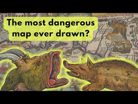
Who knew Iceland could be so dangerous? Abraham Ortelius’ redrawing of Iceland in 1585 forever changed how Europe viewed this distant island in the Atlantic. By using local sources, Ortelius was able to draw accurate coastlines and fill his new map with fascinating and terrifying information, making this one of the most beautiful and striking maps of Iceland ever printed.
Learn about the monstrous sea creatures inhabiting Iceland's waters, the gateway to hell, how foxes hunted bird eggs, and the spring of beer you can still visit today.
High-resolution map & description: https://hdl.handle.net/10037.2/603
Further reading: https://mapmyths.com/blog/islandia/
Olaus Magnus and Carta Marina: https://youtube.com/shorts/oEUlWon6RQE?feature=share
0:00 Abraham Ortelius and Islandia
0:42 A catalogue of sea monsters
3:43 The land of ice and fire: Hekla
4:39 Glaciers and other details of Iceland
6:12 Ortelius’ sources and Bishop Gudbrandur Thorláksson
7:20 Outro
Commenting disabled.
Up Next
-
06:03

Iceland - Hidden Black Beach Sand Dunes │ Part 209
-
08:49
5 Unique Experiences in Iceland: Discover Authentic Traditions and Hidden Gems
-
18:57
48 HOUR ICELAND STOPOVER | Hidden Gems & Must-See Attractions
-
29:04
13 Most Bizarre Mugshots and Their Stories
-
06:07
13 Hidden Secrets & Best Places in Reykjavik - Travel Guide Iceland
-
17:35
My Perfect Road Trip Itinerary for South Coast of Iceland (With Hidden Gems)
-
02:30

Lindesnes Trekkspillklubb - Polkan går
-
03:12
Lindesnes Trekkspillklubb Jubileumsvalsen
-
05:00

Lindesnes Trekkspillklubb nr. 1.wmv
-
03:24
Lindesnes Trekkspillklubb - Lappland
-
38:57

Iceland EP1 กลับมาแล้วจ้าหลังขอแต่งกลางห้าง! ไอซ์แลนด์หนาวจุง
-
05:32

Autumn kayaking 2022